The City Daily Photo Blog where I have my other blog, Portland (OR) Daily Photo, has a monthly theme for the first day of each month. That gives bloggers an interesting challenge. October’s theme is cemeteries and tombstone, so I knew I needed to find an interesting cemetery. A friend at work suggested Lone Fir Cemetery in Southeast Portland; I got online and discovered several lists of interesting tombstones and burials, some notated with the lot and block so that one could possibly locate the site, as well as a maps of the entire cemetery and its blocks.
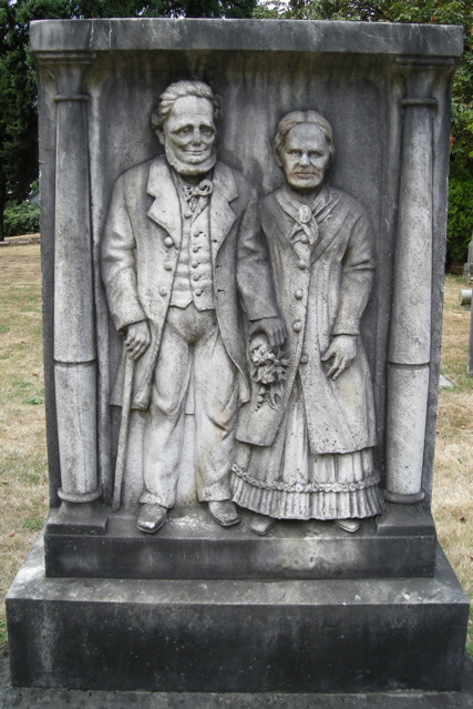
Right away I knew I wanted to find Lot 18, Block 1. So on Saturday morning a week ago, Mama, Duncan and I walked the five blocks to the car, printed information in hand. We headed across the Willamette on Morrison Bridge. Once I located the entrance to Lone Fir, I drove slowly into the beautiful, tree-filled cemetery, heading for what I felt would be the correct corner to find the burial site of James B. Stephens and his wife Elizabeth. As the car approached a 90-degree right turn, I stopped and looked over my left shoulder.
“Hot diggedty dog! There it is!” I hollered. I put the car in park, lowered the windows a bit, turned off the engine, and left Mama and Duncan to enjoy the view. You can understand why I wanted to find this toomstone, can't you? As I stood there before them, I got the distinct impression they were glad that I'd come to visit. Their eyes seemed to real to me; it was a great experience.
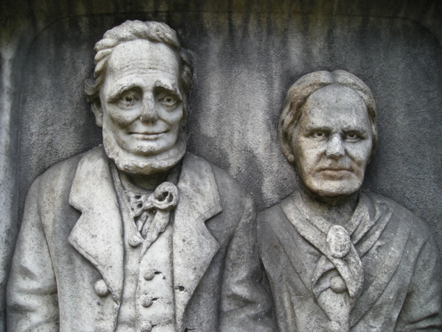
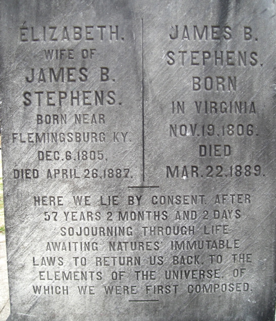
According to the Friends of Lone Fir Cemetery: "James B. Stephens came to Oregon in 1844 and operated the historic Stark Street ferry on the Willamette River in Portland. James and Elizabeth Stephens were married more than 57 years when she died in 1887. The grieving widower is said to have had the couple's photograph taken a few years before her death. Until his death two years later, James was able to visit here and imagine again holding the hand of his dear wife."

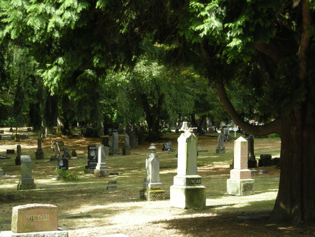
Naturally I took loads of photos elsewhere in the cemetery, too. Just around the right turn, there stood this big tree that had eaten a headstone!
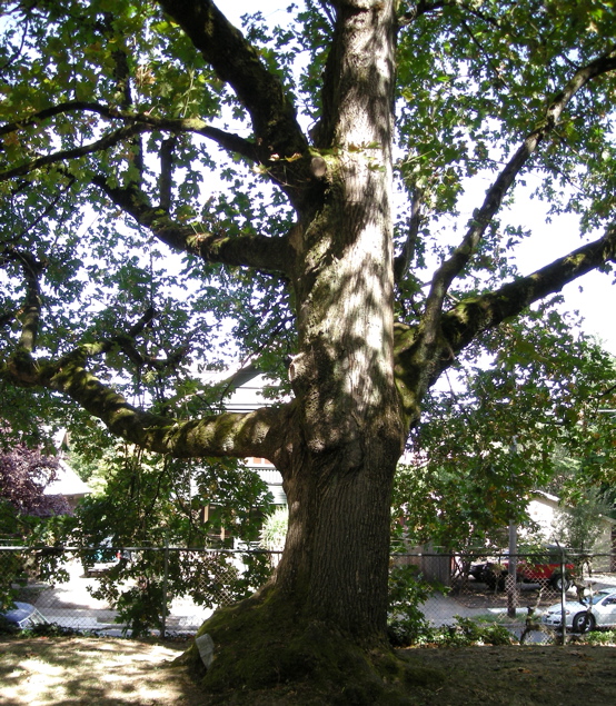
Once I got out to take a photo, I saw that the tree had actually eaten two!
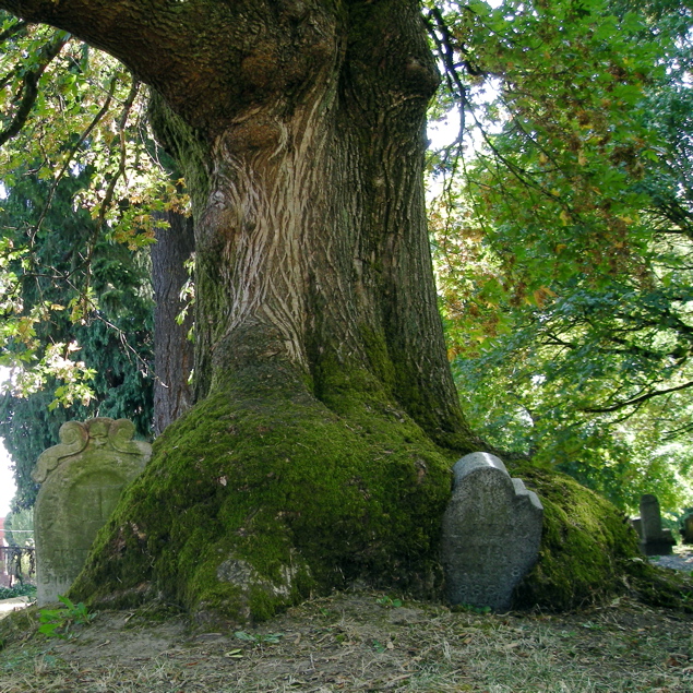
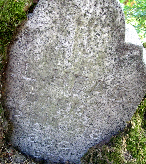
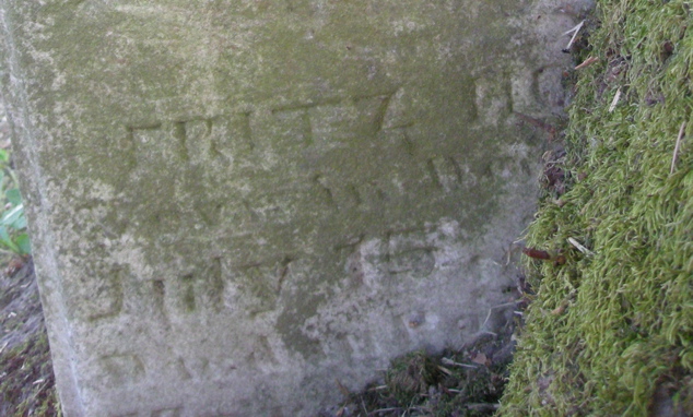
Here you see close-up shots of the the two tombstones. I can't make out much on either one, maybe 1885 on the one from the right side of the tree, maybe Fritz and July from the other one. Can you make out anything? If you have some sort of photo-enhancement-capabilites and want to play with the images, e-mail me and I'll send you the originals, uncropped, etc.
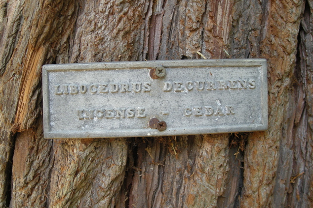
Directly opposite this tree and its tombstones, there stands a cedar with a little sign attached to it. Since it says incense cedar, I leaned in, near the bark, for a sniff. I couldn't smell anything that I'd call incense--just an outdoors sort of scent.
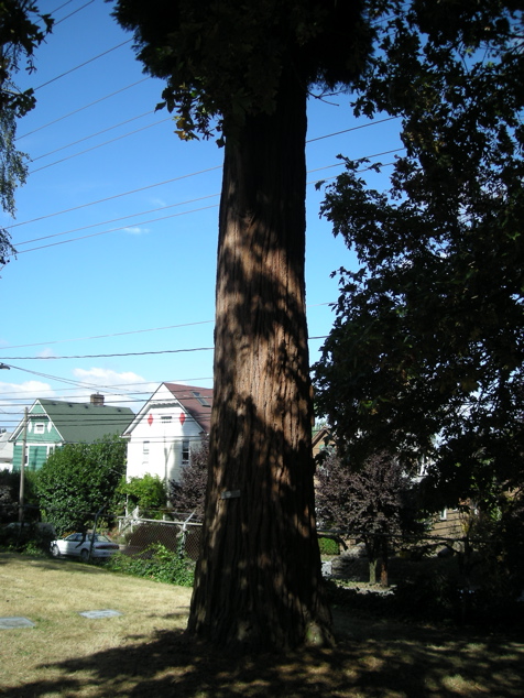
This photo doesn't really show you how big around or tall the tree is, but you can see the houses across the street from this edge of the cemetery. I believe we're looking northwest.
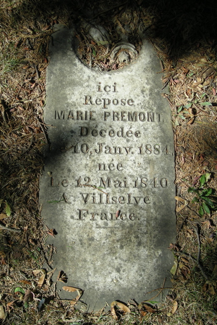
Buried in the ground between the two trees, I noticed this lovely small tombstone.
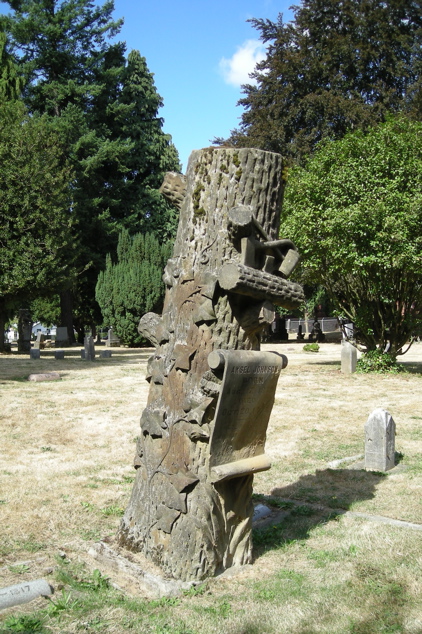
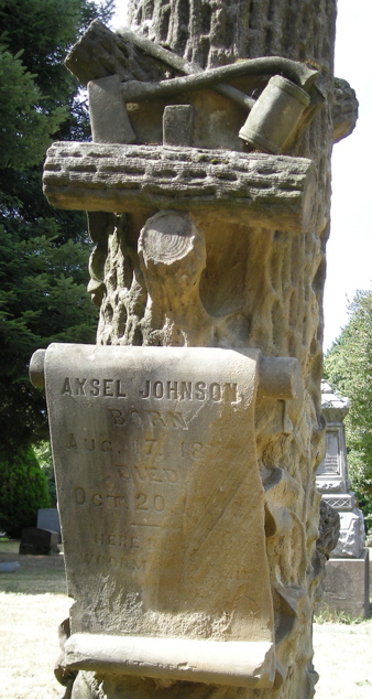
I also found quite a few interesting Woodmen of the World monuments. The way this one has settled over the years has led to erosion of the dates of birth and death for Aksel Johnson.
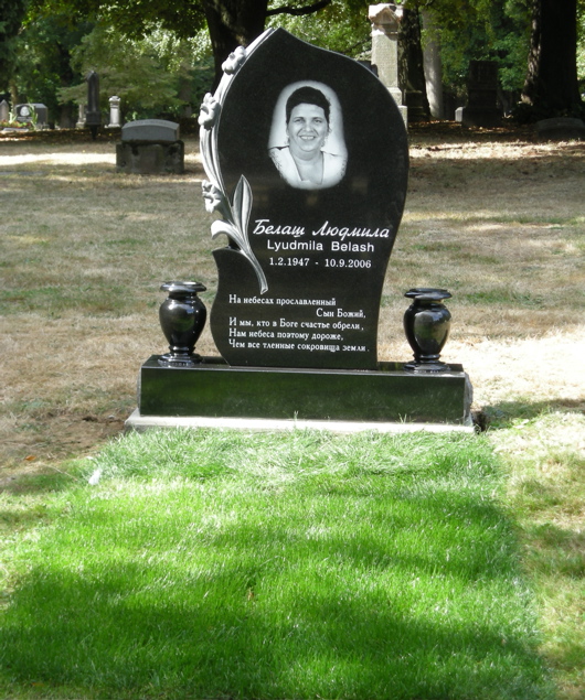
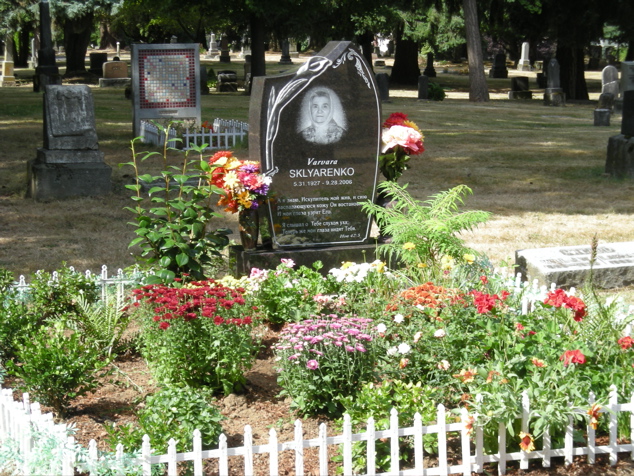
I found some interesting modern monuments, too. This first one has beautiful green grass which the family must have put down and keeps watered. It must be one of the ones mentioned by Anna Griffin in an April, 2005, Oregonian article: Within the cemetery's 30 acres, the weathered gray obelisks of Portland's founding fathers rest alongside the black-as-night granite memorials of more recent arrivals from Eastern Europe, their tombstones decorated with laser-etched pictures of the deceased and epitaphs written in Cyrillic letters.
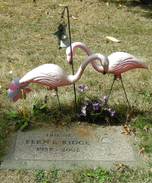
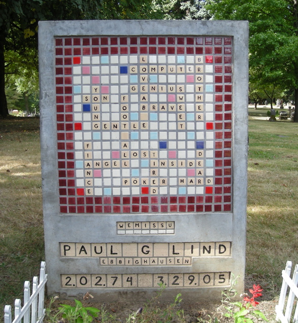
I saved another unique tombstone for the last.
Finally, here you have several articles about Lone Fir Cemetery. They are not all exactly alike. I think the county's leaves out some important recent developments.
From Wikipedia, the free encyclopedia
Lone Fir Cemetery in the southeast section of Portland, Oregon, United States is a cemetery owned and maintained by Metro, a regional government entity. Listed on the National Register of Historic Places, the first burial was in 1846 with the cemetery established in 1855. Lone Fir has over 25,000 burials over 30+ acres.
History
Lone Fir’s first burial came in 1846 when Emmor Stephens was buried several miles east of the small community of Portland. In 1854 Emmor’s son J. B. Stephens sold the family farm to Colburn Barrell with the caveat that Barrell maintain the gravesite. The following year Barrell’s steamboat the Gazelle, exploded near Oregon City killing a passenger and Barrell’s business partner Crawford Dobbins.[1] Barrel then set up a cemetery by setting aside 10 acres and burying the casualties of the explosion at the site of Emmor Stephens, calling it Mt. Crawford. Plots at the cemetery were then sold for $10 with 20 additional acres being added to Lone Fir by 1866. That year Barrel offered to sell the cemetery to the city of Portland for $4,000, but the city declined and instead Barrel sold it to a group of investors. Those investors then re-named the cemetery to Lone Fir as there was only a single fir tree at the site.
In 1903, a $3,500 memorial to the soldiers of the Indian Wars, Mexican-American War, the American Civil War, and the Spanish-American War was built at the cemetery. The Soldier’s Monument was paid for by donations by over 500 citizens. Then in 1928 Multnomah County took over control and maintenance of Lone Fir. In 1947 the county paved part of the cemetery and later constructed a building on the site. This was the location of many Chinese graves, which were removed the next year. In 2004 it was discovered that more graves likely remained at the site. In 2005 city leaders proposed removing the government building that was constructed over the graves of these Chinese immigrants and re-connecting that portion with the main cemetery. In January of 2007 Metro took over control of this section of the cemetery after a transfer from the county. On August 16, 2007, the cemetery was added to the National Register of Historic Places.
Currently the cemetery is located between Stark Street on the north and Morrison Street to the south, with Southeast 20th Avenue bounding on the west and Southeast 26th on the east. Lone Fir covers 30.5 acres and has over 25,000 graves, with over 10,000 of those unknown due to poor maintenance. It is home to the Pioneer Rose Garden.
Lone Fir’s first burial came in 1846 when Emmor Stephens was buried several miles east of the small community of Portland. In 1854 Emmor’s son J. B. Stephens sold the family farm to Colburn Barrell with the caveat that Barrell maintain the gravesite. The following year Barrell’s steamboat the Gazelle, exploded near Oregon City killing a passenger and Barrell’s business partner Crawford Dobbins. Barrel then set up a cemetery by setting aside 10 acres and burying the casualties of the explosion at the site of Emmor Stephens, calling it Mt. Crawford. Plots at the cemetery were then sold for $10 with 20 additional acres being added to Lone Fir by 1866. That year Barrel offered to sell the cemetery to the city of Portland for $4,000, but the city declined and instead Barrel sold it to a group of investors. Those investors then re-named the cemetery to Lone Fir as there was only a single fir tree at the site.
In 1903, a $3,500 memorial to the soldiers of the Indian Wars, Mexican-American War, the American Civil War, and the Spanish-American War was built at the cemetery. The Soldier’s Monument was paid for by donations by over 500 citizens. Then in 1928 Multnomah County took over control and maintenance of Lone Fir. In 1947 the county paved part of the cemetery and later constructed a building on the site. This was the location of many Chinese graves, which were removed the next year. In 2004 it was discovered that more graves likely remained at the site. In 2005 city leaders proposed removing the government building that was constructed over the graves of these Chinese immigrants and re-connecting that portion with the main cemetery. In January of 2007 Metro took over control of this section of the cemetery after a transfer from the county. On August 16, 2007, the cemetery was added to the National Register of Historic Places.
Currently the cemetery is located between Stark Street on the north and Morrison Street to the south, with Southeast 20th Avenue bounding on the west and Southeast 26th on the east. Lone Fir covers 30.5 acres and has over 25,000 graves, with over 10,000 of those unknown due to poor maintenance. It is home to the Pioneer Rose Garden.
From Metro at http://www.metro-region.org:
Lone Fir Pioneer Cemetery -- Located between Southeast 20th and 26th avenues and Morrison and Stark streets in Portland
Founded in 1855, 30.5 acres
In 1854, J.B. Stephens sold his farm, located a few miles east of the small town of Portland, to Colburn Barrell. On the property was the grave of Stephens' father, Emmor, who died in 1846. Barrell agreed to maintain the grave site.
Colburn Barrell was a partner in a passenger steamship line between Portland and Oregon City. On April 8, 1854, the boiler of their steamship Gazelle exploded while moored near Oregon City. The accident killed several people, including Barrell's business partner, Crawford Dobbins, and a passenger. Barrell buried the victims near Stephens and set aside 10 acres as a cemetery. He named the cemetery Mt. Crawford in honor of his friend, Crawford Dobbins.
By 1866, 20 more acres were added to the original cemetery. Burial plots sold for $10. Colburn thought the cemetery should be owned by the city of Portland and offered it to the city for $4,000. The City Council turned down the offer, citing the location was too far from town. There were no bridges crossing the Willamette River, and the mule-powered Stark Street ferry was slow. Coupled with muddy roads, a funeral procession would be a weary trip at best. The cemetery was eventually sold to Portland investors in 1866 and the name changed to Lone Fir Cemetery for the solitary tree standing on the site.
Today, Lone Fir Cemetery is a wooded, landscaped arboretum in the heart of Portland. More than 25,000 people are buried here, from the familiar (Curry, Dekum, Hawthorne, Lane, Lovejoy, Macleay) to the unknown. Decay, neglect and poor record keeping in the early years have led to an estimated 10,000 unknown graves. A visit to Lone Fir Cemetery will reveal the region's rich history.
"All nations are represented, all grades of society, all states of wealth and standing. Rich lie here and poor, employer and employee, those with virtue and those without. Death has a way of banishing snobbishness, of cultivating comradeship."
—D.A. Lund, Lone Fir: Silent City of the Dead
From Multnomah County:
A Brief History of Lone Fir Cemetery
In 1854, JB Stephens sold his farm to Colburn Barrell. Within this farm was the grave of Mr. Stephen's farther Emmor Stephens who died in 1846. As part of the sale, Mr. Barrell promised to keep the grave on the property.
Colburn Barrell was a partner in a passenger steamship line running between Portland and Oregon City . On April 8, 1854 their ship, The Gazelle, exploded due to a boiler problem onboard while at a wharf in Canemah. The accident caused the death of several people including Mr. Barrell's business partner Crawford Dobbins and a passenger, David Fuller. Barrell buried both of these men on this farm near the grave of Emmor Stephens and he set aside ten acres as a cemetery, naming it Mount Crawford.
In August 1855, the county Surveyor , AB Hallock platted this area and filed it under the title of Mount Crawford Cemetery . Mr. Barrell took Lot 1 Block 1 for his family. In 1862, he donated Block 5 to the City Fire Department and sold two blocks at a low price to the Willamette and Harmony Lodges of the Masonic Order.
In 1865, thirteen acres were purchased and in 1866 seven more were added to the original cemetery. Today the total acreage of the cemetery is 30.50 acres.
Colburn Barrell felt the cemetery should be owned by the City of Portland and offered it to them for $4,000. The City Council turned it down because the cemetery was so far from the City.
When the City refused to buy the cemetery, Byron P. Cardwell, Levi Anderson, Robert Pittock and other Portland residents purchased it for $4,000 and incorporated it on July 26, 1866 . At that time Mrs. Aurelia Barrell suggested the name be changed to Lone Fir Cemetery and her suggestion was adopted.
In the fall of 1903 the Soldier's Monument was unveiled. The cost was $3,500 and the amount was contributed by more than 500 people. It was erected as a monument to soldiers of the Civil, Spanish-American, Mexican and Indian Wars.
Interest in the cemetery faded and although some lot owners and descendents of Pioneers tried to maintain it, the cemetery was run-down to a point where Multnomah County assumed control in 1928. The county restored the tract as a place of restful beauty.