Thursday, January 31, 2013

A. E. Doyle's Bank of California Building, No. 6

Click here for a trip to City Daily Photo, transporting you around the world every day.

DSC_0435_rz

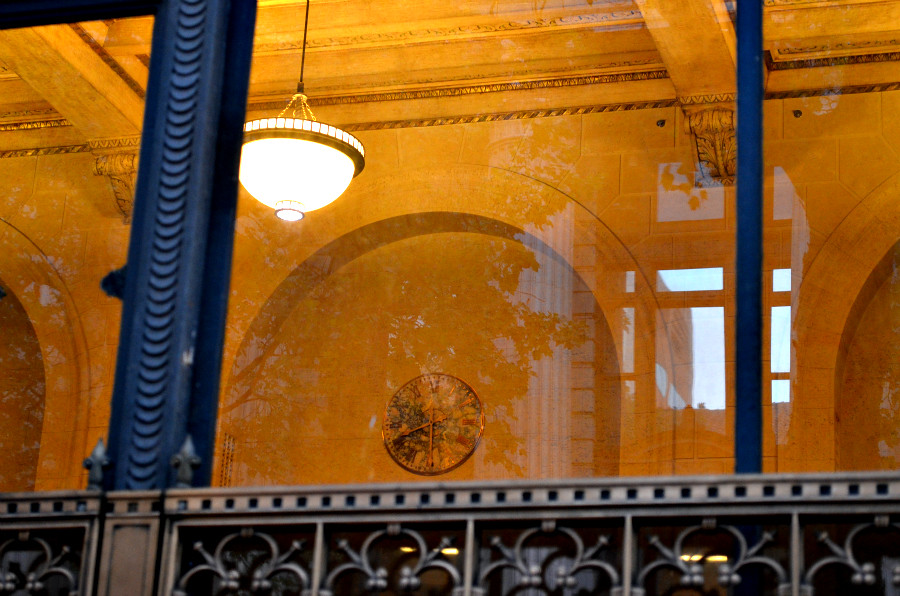
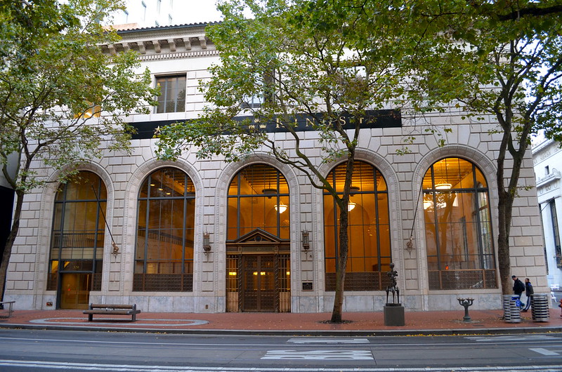
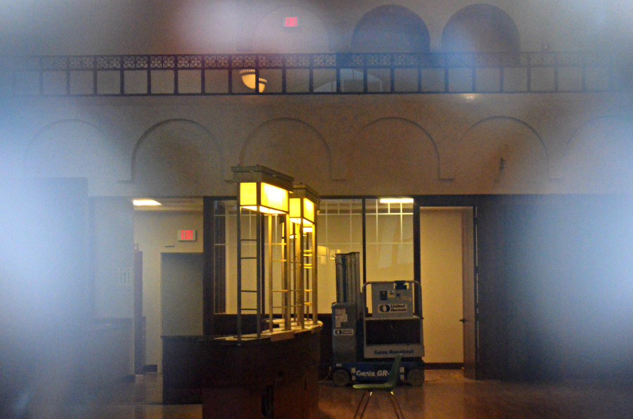
Looking northeast at the end of the lobby, in a photo that I took on October 25, 2012. Thankfully, the arches are still there. Look at the photo below for a comparison.
  DSC_0391_rz

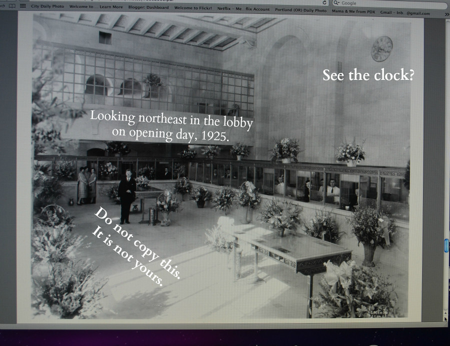
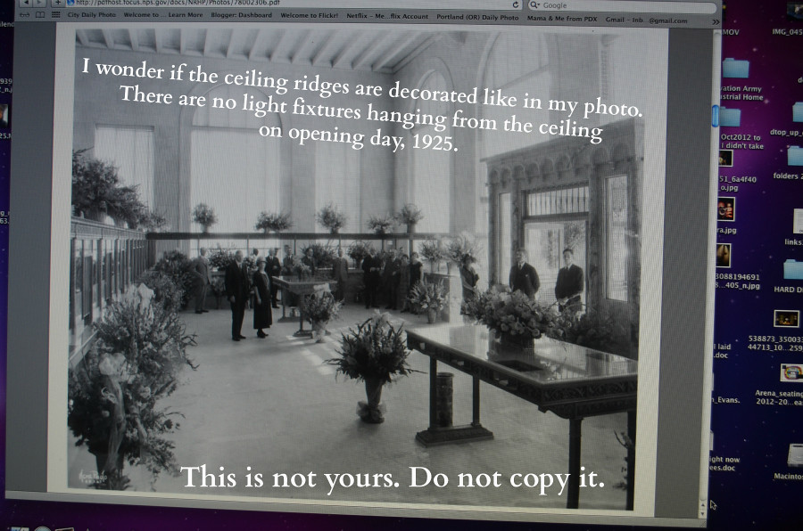
Looking northeast at the end of the lobby, in a photo taken in 1925, on opening day.

Picture yourself entering this huge, open lobby. Which setting would have overtaken your senses? OK, I know the photo at the top leaves a bit to the imagination since I couldn't get such a wide view, and there is a piece of equipment sitting on the floor. Even if I had been able to see it all and could have provided you with a better comparison, would that have made a difference? Not to me. I'd still have to vote for the breath-taking view in the vintage photo. And I still wonder how the sun-filled lobby smelled with all of those bouquets on site.


DSC_0388_rz

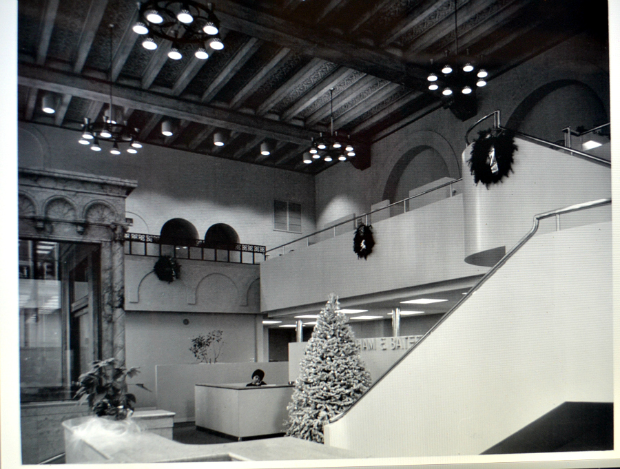
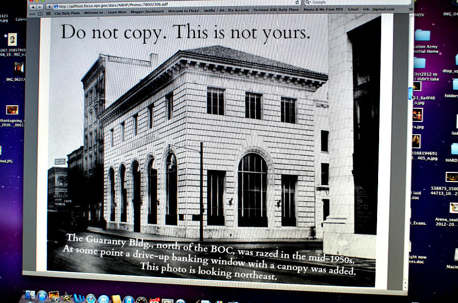
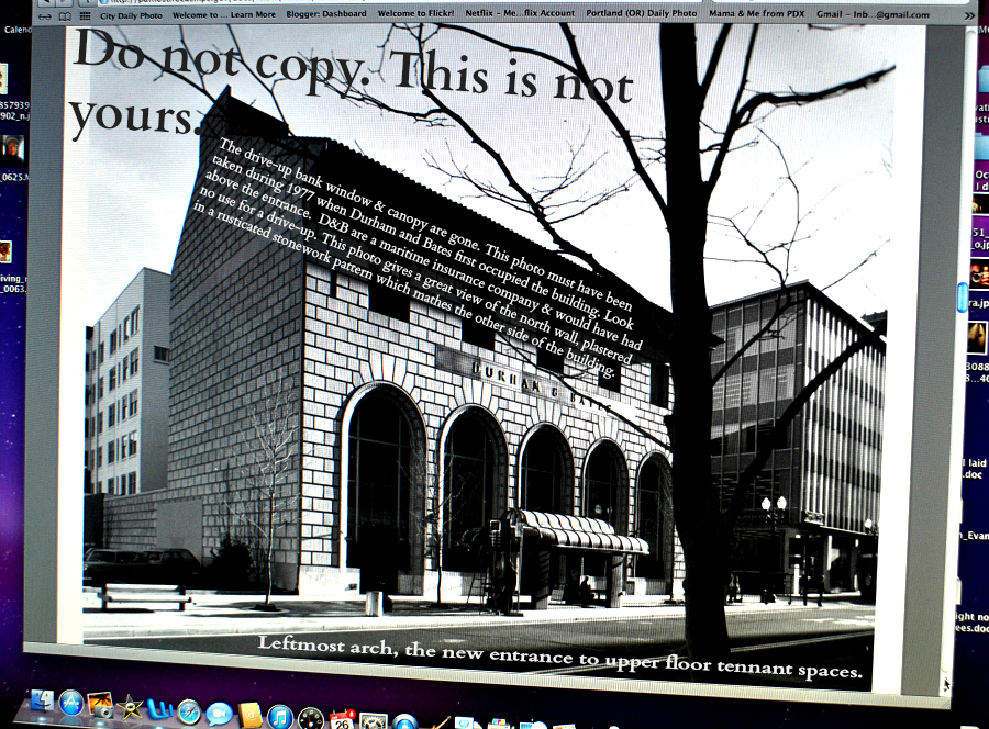
Here's the lobby as it was when the application was made, in a photo taken in 1977 or 1978. Durham and Bates would have been the occupant at that time. The gorgeous glass and what looks to be marble shape on the left side of the photo is the entrance portico situated on the west side of the lobby. The back of this photo says: Interior view of Old Bank of California Building looking Northeast in former banking lobby, now office space, showing extended mezzanine. 

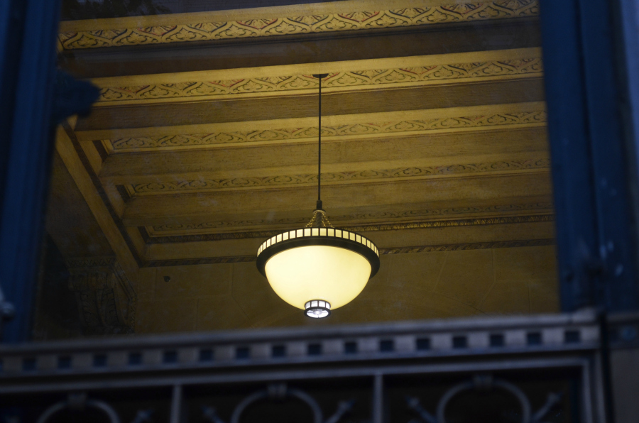
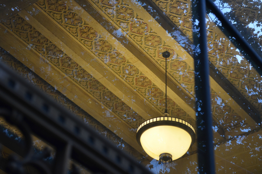
Here's information about the building's interior from the paperwork turned in to the National Register of Historic Places: The building's main floor, originally the banking lobby, tellers' cages, and office platform, was designed as a grand two-story room with a handsome ornate coffered beam ceiling.The east wall has blind arches which echo the window forms of the west wall and, as with other Renaissance forms, are carried out in fine detail. As on the exterior, the interior finishes demonstrate the skill which had developed in the fabrication of imitation materials at the time of construction. Interior surfaces are almost entirely cast materials--an integrally colored plaster, formed to look like travertine marble. Only the Escollette marble vestibule, marble floor of the banking lobby, and the tellers' counters, which have been removed, are of genuine materials. The floor incorporates three kinds of marble--Hungarian Red, Taverne Le Pink Tennessee, and Jaune Nile. At some subsequent time, the colored "travertine" plaster was painted a rather yellowish color. During the recent remodeling, it was repainted to a beige tint more akin to the original color. 

In adapting the former banking room for use as office space, the original 16' wide mezzanine along the north wall was extended south against the east wall to the south wall. An additional free-standing stair was added to connect the new mezzanine to the main floor. Architects for the renovation--Fletcher, Finch, Far and Associates--designed all partitions, railings, and other added forms in a contemporary style in order to strongly contrast with the original building forms. This was further carried out by the selection of contrasting colors for the new design elements, with no attempt being made to copy the renaissance colors and forms of the original design. 

Wednesday, January 30, 2013

A. E. Doyle's Bank of California Building, No. 5

Click here for a trip to City Daily Photo, transporting you around the world every day.

DSC_0567_rz

An eatery, The Original Dinerant, occupies the street level of the building to the north of the Bank of California. The BOC is just out of sight at the right of this building, next to the black-faced wall visible near the current-day TriMet bus shelter you see lit up for the night-time users of mass transit. Someone waits for a bus and appears to have a bicycle to place on the bike rack attached to the front of the bus.
  DSC_0436_rz

Here's the Bank of California, just south of The Original Dinerant--notice the black-faced wall.

Vintage photos, part of the documentation used to place architect A. E. Doyle's Bank of California on the National Register of Historic Places. The application is dated as received on February 15, 1978, and approved on March 14, 1978.
  DSC_0384_labeled_correctly

Vintage photo shows the Guaranty Building which was adjacent to the Bank of California and north of it. The back of the photo says that it was taken in 1924. Since the grand opening photos are dated 1925, it may not have actually been occupied at the time this photo was taken. I wish I had a photo of the north end of the building, which was exposed with the demise of the Guaranty Building, complete with the drive-up window and the canopy. Below is the next best thing.
  DSC_0385_crp_rz_labeled_correctly

The north end of the Bank of California, taken during 1977 probably. Note the placement of the older style TriMet bus shelter here on this section of SW 6th Avenue--part of the then brand new Portland Transit Mall. In the second photo on today's post, a bench occupies this spot, put there when the Transit Mall was rebuilt. And you've already seen the style of bus shelter which replaced these iconic ones, in the top photo today. 

From the paperwork submitted to the National Register of Historic Places:

Since the Bank of California's move to a new building in 1970, the structure has been occupied by The Security Bank of Oregon and, subsequently, the Oregon Bank. In 1977, ownership passed to Bankside Investors for occupancy by Durham and Bates, Inc., an insurance firm of pioneer beginnings in the Portland area. Since its construction, the exterior of the building has remained substantially unaltered, the only significant change being the addition of a drive-up banking window and canopy at the north end of the building. This was made possible by the razing of the six-story Guaranty Building which occupied the property immediately to the north until the mid-or late1950s. At this time, the newly exposed north wall was plastered in a rusticated stonework pattern simulating the west and south building elevations.

The imposing west facade of the bank building has five large arched windows which extend from the ground floor to a height of 28 feet above the sidewalk in recognition of the two-story banking lobby inside. Centered above these arches are smaller rectangular windows which serve the second floor office space almost 35 feet above the ground floor. Window frames are of painted steel. Above the second floor windows is a marble frieze and bracketed cornice which supports the Cordova Terracotta tile hipped roof typical of the Pallazzo style. The imposing rusticated "stonework" of the exterior walls and cornice are, in reality, cast terra-cotta executed with excellent craftsmanship. Only the marble base course and frieze are genuine. 

The entrance to the building is through a handsome bronze portico set in the middle arched window opening at the west facade, and boasts a pair of bronze gates which can be slid in front of the double entrance doors. The original bronze-framed doors were removed a number of years ago and replaced by automatic tempered glass doors.

Recent modifications to the building, made just prior to occupancy by the present tenant, include the removal of the added drive-up window and canopy at the north wall, and the filling in of a door which was cut through to the parking lot.

A new entrance was installed in the northern-most window of the west wall to provide access to a new lobby serving the upper floor
tenant spaces. Presently, theTri-Metropolitan Transit District has contracted for the widening and brick-paving of the sidewalk on SixthAvenue. The brick texture and color, together with soon-to-be-installed trees and street furniture should further enhance the handsome building.

Tuesday, January 29, 2013

A. E. Doyle's Bank of California Building, No. 4


Click here for a trip to City Daily Photo, transporting you around the world every day.

DSC_0444_altered


Look at the clock, there, centered inside one of the arches on the back wall of the bank's lobby.


DSC_0389_crp_labelled_clock

I think it's the same clock that can be seen in this vintage photo. What do you think? The unusual clock face, what looks like brass Roman numerals and a brass ring around the edge of the clock face--they all match closely, as best I can tell from these two photos.

Monday, January 28, 2013

A. E. Doyle's Bank of California Building, No. 3

Click here for a trip to City Daily Photo, transporting you around the world every day.

DSC_0449_rz

The ceiling and one of the light fixtures.
  DSC_0459_rz

A closer view, from a different angle.
  DSC_0383_labeled

Another vintage photo. From the National Register of Historic Places application for the Bank of California--I could not find the photos online anywhere except in the PDF, so I took photos of the photos with my camera because the thought of not being able to share them with you saddens me immensely. Please do not copy and paste this photo. Thank you.

Saturday, January 26, 2013

A. E. Doyle's Bank of California Building, No. 2

Click here for a trip to City Daily Photo, transporting you around the world every day.

DSC_0429_rz

Standing at the front door, I took this first photo after I got off the bus. Excited to see something inside, anything at all--I'd never been able to see anything through the doors. So, these light fixtures and what look to me like maybe bank teller stations tickled me, big time. 

DSC_0430_rzNext I walked to the south end of the building to look in the first window there, after I walked around the corner onto SW Stark. I like the perspective of this view which shows those light fixtures and the counter as seen through part of the brass metalwork along the bottom of the arched window. The juxtaposition of the light fixtures with each other intrigued me. 

DSC_0431_rzCurious and still not satisfied that I'd seen all I could see, I moved a step or two and took one more photo through the metalwork on the window--this one. I believe I saved the best for last. Look at that curved counter! The metal supports of the light fixtures! Well, it looks like metal to me. And you can tell that someone's been in there and left a chair and a piece of equipment. Left the lights on, too, thanks be to the architecture-lovin'-gods!

DSC_0396_do_not_copyA vintage photo of the building--on the back it says "View looking Northeast at the corner of 6th Avenue and Stark Street showing Old Bank of California Building." and "Bank of California Building (Old), 330 SW Sixth Avenue, Portland, Multnomah County, Oregon, 3 of 8, Curtis Finch photo 1977. West and south elevations. Fletcher, Finch, Farr & Associates, 920 SW Thirteenth Avenue, Portland, OR 97205." From the National Register of Historic Places application for the Bank of California--I could not find the photos online anywhere except in the PDF, so I took photos of the photos with my camera because the thought of not being able to share them with you saddens me immensely. Please do not copy and paste this photo. Thank you. Oh, by the way, notice that curved-topped structure at the right corner of the building--that's what all of the mass transit stops used to look like downtown, on the Transit Mall. I miss them and their shape immensely.

Friday, January 25, 2013

A. E. Doyle's Bank of California Building

Click here for a trip to City Daily Photo, transporting you around the world every day.

DSC_0439_edited

Here's the back story about the upcoming posts of architect A. E. Doyle's Bank of California on the corner of SW 6th Avenue and SW Stark. I'm not going to call it any of its other iterations because I'm so fond of Doyle's work and figure he deserves respect from me in my posts about his buildings. For years I have felt this building to be one of the loveliest in downtown Portland, so pleasing to the eye in its symmetry and size, the shapes of the windows, the bronze metalwork along the bottom of the arch windows and at the heart of the door, the cast terra cotta and marble exterior. 

Here we have two photos that I took on October 25, 2012. I got off the homeward bound bus to take them and the ones you'll see over the next few days.

DSC_0440_editedI go this way Monday through Friday after work, but I never get off the bus here--there's no reason--I've only been on it a . At least there wasn't until the day before I got off and took these photos. As we passed by, my back to this side of the street, I noticed out of the corner of my eye that there were lights on inside the building which has not been in use since I moved to Portland in June, 2006, that I know of anyway. Astonished, I swiveled my head from right to left to make certain that I had really seen lights on in the Bank of California. 

I found this online which explains why the lights were on inside the Bank of California: 

Historic Bank of California Building for lease 330 S.W. Sixth Ave. POSTED: Monday, December 17, 2012 at 12:01 PM PT BY: Lee Fehrenbacher Tags: A.E. Doyle, Bank of California Building, historic buildings 

The historic Bank of California Building in downtown Portland, which opened in 1925 and was designed by noted Portland architect A.E. Doyle, is for lease. The Italian Renaissance Palace Style structure was added to the National Register of Historic Places in 1978. 

And I found the 1978 National Register of Historic Places Inventory - Nomination form online, which makes for some fine reading about the building. I cannot get the link to work! So, I don't know if this will help or not, but in case you're interested, here it is for you to copy and paste: http://pdfhost.focus.nps.gov/docs/NRHP/Text/78002306.pdf
   

Three photos for you to enjoy:

Thursday, January 24, 2013

Seen in Northeast Portland

Click here for a trip to City Daily Photo, transporting you around the world every day.

DSC_0563_picmonkey

Actually, this is one half a block inside Northeast Portland. The street behind the man is East Burnside which is the street that divides Portland's north from south. The street on the left of the photo is NE Martin Luther King Jr. Blvd. I took this photo on December 8, a Saturday. I was out and about, walking and looking and taking photos on a dry-at-the-moment Saturday morning--before I ended up at Tuba Christmas at Pioneer Courthouse Square.

Since this is where on my morning commute I change from one bus to the other, or from one bus to the streetcar,  I am thankful that I've never before seen this man feeding the pigeons. 

Wednesday, January 23, 2013

The MAX Yellow Line at SW 6th Avenue and SW Pine

Click here for a trip to City Daily Photo, transporting you around the world every day.

DSC_0640_crp_rzd

The MAX Yellow Line pulls in at the station beside the Big Pink, downtown Portland, on SW 6th Avenue and SW Pine. A couple of guys walk towards it as it slows and another one buys his ticket at the kiosk. On Saturday, January 19, I got on board before it pulled out. My plan, to ride to the Rose Garden Arena for the Portland Trail Blazers' basketball game against the Milwaukee Bucks. This is the train that I got off and then took the photo of the Rose Garden Arena in the fog, Monday's post. 

On ball game days during the week, I catch a ride to the Rose Garden Arena at the MAX Yellow Line station at Pioneer Courthouse Square, after eating cheap at McDonald's or Subway and walking the four blocks to the station. On game day Saturdays or Sundays or holidays, I catch the MAX Yellow Line here because it's closest to where I get off either the 12 or the 19 which I had caught a block and a half from my apartment. Mass transit works pretty doggone good, if you play it right. 

Tuesday, January 22, 2013

Seen outside the Rose Garden Arena, January 19, 2013

Click here for a trip to City Daily Photo, transporting you around the world every day.

DSC_0684_cropped

Before the basketball game, I walked by the crowd lined up at various doors as the awaited the arrival of 6 p.m. These doors are the main ones at the south end of the arena. The door I use is just to the right of the right edge of this photo, maybe 12 feet away. I exit usually at the right-most of the doors in this photo where the person in the red and white jacket waits, unless I remember to go out another doorway which is usually devoid of a crowd and is also to the right of these. I don't go out the door I use as my entrance because it is a single door which opens onto a one-way ramp with a railing--a total bottleneck. 

The upper level circular area is where folks who have paid to eat at the pre-game buffet because their more expensive ticket includes the food go to sit with their food. I've been there a couple of times when the Blazers had special events for season ticket holders. The view is pretty good and would be better if the grain elevators were not right across from the arena. However, I'm sure that business-wise, for the Willamette River, the grain elevators are a good thing. Can't run an economy on the whim of professional basketball. 
  DSC_0689_resized

Ah. The entry process--looking in your bag/purse after you set it on a narrow folding table, going through the metal detector, being wanded if you set off the metal detector, and having your ticket scanned--has begun. Tonight I'm on my way to a different entrance than the one I described above because I wanted to pick up my LaMarcus Aldridge NBA All-Star bobble head--the Rose Garden Arena season-ticket-holder help center is at the north end of the arena, so I decided to go get it before heading for my seat. 

You can see the folks at the tables in the eating area on the second level. I'm sure it has some sort of official name, but I can't remember for sure. The first time I went up there for a season ticket holder event, I ate juicy and tender roasted buffalo, carved from a huge hunk of meat and placed onto my plate by the server.   

By the way, the smoking balcony which I find troubling because of its proximity to my season ticket seat and the way the hall between me and the bathroom fills with cigarette smoke, especially at halftime, is beneath the pointed roof you see in the second photo. When it's time to renew my tickets next season, I'll be looking for somewhere else on the south end of the arena, somewhere affordable and away from that smoking balcony. I've complained several times when the smoke has come out into the arena so that I could smell it at my actual seat. The floor manager to whom I gave my info said to complain every single time I feel that the smoke is overwhelming. Well, if I didn't have to wait for him out in the smoke, I'd certainly be doing that!

Monday, January 21, 2013

Rose Garden Arena, before a game

Click here for a trip to City Daily Photo, transporting you around the world every day.

DSC_0679_shared

Saturday, January 19, I took this photo after I got off the MAX Yellow Line and took this photo before I crossed the street to go inside for the basketball game. While the arena has always reminded me of a UFO, never was that feeling as strong as seeing it lit this way in the fog. 

Sunday, January 20, 2013

Seen outside the Rose Garden Arena, after the game

Click here for a trip to City Daily Photo, transporting you around the world every day.

DSC_0230_cropped

I took this photo Saturday, January 19, after the basketball game. The Milwaukee Bucks won, not us. However, I am a fan, no matter what. 

We don't normally have fog like this, so I am happy to have had the opportunity to take a few photos out in it. Looking southwest towards the Willamette River and downtown Portland, you cannot see the Steel Bridge or the grain elevators--much less the lights of downtown--the fog's that thick. 

Bits I discovered online about the sculpture. 
  • The Little Prince, by Ilan Averbuch. Copper and steel, 1995. 
  • The Little Prince is a partially buried copper crown located at the south end of the arena in the Rose Quarter. It is a piece about imagination, desires and aspirations, conquests and struggles. It is the job of the viewer to create the story that goes along with the crown. Is it a victory and position of honor waiting to be claimed, or is there another story? Only the viewer can say.
  • Ilan's inspiration for this piece was the "Little Prince" by Antoine De Saint-Exupery, in particular, the first chapter where he talks about his drawing of a boa constrictor swallowing an elephant being misunderstood as a hat.
  • Ilan Averbuch's "Little Prince" and the Portland Trailblazer's Rose Garden Arena. Portland, Oregon . . . legend has it that the crown will be stood upright when the Blazers with their next championship.
  • The Little Prince, 1995, is a gigantic fallen crown, an image of a ruin of ancient majesty, of one-time splendor, and a version of another recurring theme in Averbuch’s work: the obsolescence of the monumental, former monuments in the soil, like ancient relics.
  • The Little Prince (Ilan Averbuch, 1996) is a copper crown, standing 15 feet tall in front of the Rose Garden. Inspired by the French children's story by Antoine De Saint-Exupery, the artist asks that you use your imagination to think of a story behind the crown. The crown is resting on its side perhaps waiting as a prize to be claimed or as a symbol of a triumph to come.
DSC_0229 Here's another view of it. It's on a bit of an elevation from street level, the height of which is well-represented here by its juxtaposition with the bottom windows of that double-decker bus from Kells Irish Restaurant & Pub which is in downtown PDX. DSC_0575 Another photo of "The Little Prince" that I took on October 16, 2010. DSC_0574 And one more, with a part of the Rose Garden Arena visible on the other side of it.

Saturday, January 19, 2013

Seen in downtown Portland, backlit cyclists

Click here for a trip to City Daily Photo, transporting you around the world every day.
DSC_0508_cropped

December 5, 2012, the night I walked to Pioneer Courthouse Square between homeward-bound buses in order to get a good photo of Portland's Christmas tree, I saw these two waiting in the traffic while I waited to cross the street. There's a good chance they are headed east to cross the Hawthorne Bridge. 

I cannot remember which intersection this is, so I've looked at the photos before and after it, in the download on my iMac. I've looked at the trees and the light fixture on the wall in the photo. I've made my best guess and have Google-Mapped SW Broadway and street-viewed SW Broadway and SW Salmon. There it is! Yep, they're headed east on SW Salmon which could eventually put them on the Hawthorne Bridge, or to some north/south thoroughfare that would take them to other bridges open to bicycles in Portland. Pretty cool. 

If I were younger, I often wonder, would I ride a bike here? I honestly do not know. I did ride a bike to the grocery store and to acting classes back in 1971-72 in Kansas City, Missouri--my neighborhood was in between the oldest area of KCMO and the downtown area, on bus lines and with wide streets. So, I rode the bus to work and the bicycle on errands, after I had sold my car. Younger, more limber, less fearful of consequences because, like most youth, I knew nothing could ever happen to me because it would only happen to someone else. 

Friday, January 18, 2013

Seen on the Hawthorne Bridge - don't blink or you'll miss him!

Click here for a trip to City Daily Photo, transporting you around the world every day.

DSC_0455_cropped

I've seen this man many times in the mornings before 8 a.m. while I wait to cross the intersection when the traffic signal changes. He pedals east on Hawthorne after he's come off the bridge that crosses the Willamette River. His slender legs quickly bend and straighten, and the recumbent bicycle skims the pavement at full speed. A tall flag attached to the back of the bicycle whips side-to-side, in unison with his pumping legs. There's a mouth-locked-open sort of a grimace/smile on his face, along with a look of concentration which reminds me of a man plotting his next move on a chessboard.  To change lanes, he uses side view mirrors with the certainty of a mongoose locked onto the movements of a cobra. Many days after 5 p.m. while I wait for the bus, I've seen him heading west at the intersection of SE Grand Avenue and SE Madison, looking just the same as he does in the morning. His energy level appears undiminished by however he spent the last nine hours.  

All of that is to say that it's fitting that the man on the bicycle is a blur in this photo. On January 8, as I stood enjoying the view at the railing near the bus stop on the bridge, I looked east and noticed him coming toward me. I knew he'd be on me before I could take a photo in that direction, so I put the camera up to my eye as I turned to wait for him and pushed the button as he blew by me. 

Now that I look at the photo on the iMac, I wonder where the bike's flag has gone.


Thursday, January 17, 2013

Seen in downtown Portland

Click here for a trip to City Daily Photo, transporting you around the world every day.

DSC_0496_cropped

After I had walked over the Hawthorne Bridge on January 8, I continued towards the bus stop at SW 2nd Avenue and SW Main so that I could catch my first bus of the two it takes me to get home. Before I got to that bus stop in the next block, I noticed the lights of a bus which had stopped behind this lady on the bicycle, shining on her. Naturally I had to take a photo, then when the light changed, I hot-footed it for the next corner because the bus behind her was the one I wanted to catch!

You can see how prepared she is for our usual rainy winter weather, with her hooded, bright green rain coat and her tall rubber boots. It alarms me that she doesn't have a helmet--mothers get alarmed by stuff like that. I'm glad to see that she has a light on the back of the bicycle--there near where her raincoat is reflected in the red bike's aluminum (I suppose) fender. What do you think about the angle of the handlebars? Pointed straight up, it seems to me. I hope I come across here again some time so that I can take another photo to compare with this one. 

Once I saw the photo on the iMac, I decided that it had turned out much better than I had expected. Here are the reasons I believe that to be true:

  • The headlights shine into the intersection, making a slight shadow of the lady and her bicycle.
  • The dashes that outline the bike lane follow the angle of SW Main as it departs the Hawthorne Bridge and continues westward up  the street. I'm usually up in a bus and don't get to see the street like this.
  • Also, it's neat that the trees still have lights on them--something left over from the holidays.
  • Finally, I like the pedestrians who've crossed at the intersection. I imagine each one feels as good as I remember feeling about no rain on that particular evening. The last woman in the group on the left of the intersection wears stiletto-style black boots. Amazing that anyone willingly puts those on their feet and heads out to work all day in them. Even when I was young and slim, I couldn't bear the thought of doing that to my feet. 

Wednesday, January 16, 2013

Out with the girls on New Year's Eve afternoon

Click here for a trip to City Daily Photo, transporting you around the world every day.

PicMonkey Collage

Julie from Minnesota, Donna from Alabama, and I from Mississippi met at Brasserie Montmartre in downtown Portland for a tasty, time-consuming-cause-we-wanted-it-to-be lunch. Good food. Good friends. Talking. Laughing. Enjoying. Then, we walked a few blocks to the Living Room Theater and bought our tickets for "Old Goats." With time to spare, we browsed at nearby Powell's Books before returning to the theater to watch what turned out to be a highly entertaining movie.

Tuesday, January 15, 2013

Seen on the Hawthorne Bridge

Click here for a trip to City Daily Photo, transporting you around the world every day.

DSC_0472_altered_picmonkey

On January 8, I stood on the westbound approach of the Hawthorne Bridge and looked towards downtown, admiring the night sky and the lights, the bridges and the traffic--vehicles, bicycles, and pedestrians. Intrigued by the various views, I noticed some of the  of the Hawthorne Bridge's truss spans between the upper and lower decks of the Marquam Bridge (which is also Interstate 5). Since I liked what I saw, I picked up the Nikon D50 hanging around my neck and took this photo.

An 18-wheeler zooms south on the lower Marquam Bridge deck. On the upper deck, a light-colored van or SUV heads north. The Willamette River ripples and shines between the Hawthorne Bridge supports, reflecting the well-lit Willamette River. The cone-shaped top of the KOIN Tower and the upper floors of the Wells Fargo Building stand tall in downtown. At the western end of the street with the cars parked along its north side, there's a single story building with a sort of patio in front of it, a low railing at the edge of the patio to keep folks from falling into the Willamette, and a very tall evergreen tree right across the patio from the building. That building is a fire station. The firefighters serve Portlanders on dry land and river water. 

About the Hawthorne Bridge, from the Multnomah County Web site:

Hawthorne Bridge 

Originally constructed in 1910, the Hawthorne Bridge is the oldest operating vertical lift bridge in the United States. The 1,383-foot long Hawthorne Bridge is one of Portland’s busiest bridges, safely carrying approximately 30,000 vehicles and untold pedestrians and cyclists across the Willamette River. Vertical clearance for river traffic is limited and approximately 200 openings per month are required for this vertical lift bridge.

Like other vertical lift bridges, the Hawthorne Bridge uses a system of counterweights and cables to move the lift span straight up and down. The operating system is mostly original, but the electrical power and control systems—which were installed in 1975—were upgraded in 1999. Hawthorne’s counterweights each weigh 450 tons and are supported by the bridge’s two towers, which rise 165 feet above the bridge deck. The Hawthorne Bridge’s main span can be raised 110 feet to allow vessels to pass underneath. On average, an opening of the Hawthorne Bridge is 8 minutes long.

Major structural modifications on the truss spans have included: 
  • Removal of the original timber deck and sidewalk.
  • Installation of open steel grating deck and concrete and aluminum sidewalks. 
  • Widening the sidewalks from 6 feet to 10 feet to allow greater room for pedestrians and cyclists. This resulted in the overall deck width extending out to 72 feet.
The Hawthorne Bridge was designed by Waddell and Harrington, Consulting Engineers from Kansas City, MO and constructed by the Pennsylvania Steel Co and United Engineering and Construction and Robert Wakefield. It opened to traffic on December 19, 1910. 

Hawthorne Bridge statistics
  • Year built: 1910
  • Overall structure length (main span, approaches and ramps): 3,552 ft
  • Width: 73 ft Center height above water: 49 ft
  • Designed by: Waddell and Harrington, Kansas City, MO
  • Constructed by: Pennsylvania Steel Co., United Engineering and Construction, and Robert Wakefield.
  • Main river span: The main river span is made up of six spans for a total length of 1,383 ft. The three spans east of the lift span section are each 209’3” long; the lift span is about 477 ft long; the tower spans (which flank the lift span) are each 244’3.5” long. The towers rise 165 ft above the bridge deck and support the bridge’s two counterweights, which each weigh 450 tons. 
  • East approach: Consists of three separate ramps: the Madison Street Viaduct, the Hawthorne Street Viaduct, and the Water Avenue Ramp. The Madison Street Viaduct is 1,290 ft long, carries two lanes of westbound traffic toward the bridge and is constructed of simple-span steel girders supporting a concrete deck on reinforced concrete columns and caps. The Hawthorne Street Viaduct is 1,250 ft long, has construction similar to the Madison Street Viaduct and carries two lanes of eastbound traffic away from the bridge. The 549-ft Water Avenue Ramp is a two-lane, two-way ramp built in 1992 that allows eastbound traffic to exit the bridge to Water Avenue, and allows westbound traffic access to the bridge from Water Avenue.
  • West approach: Approximately 330 ft long, the west approach is made up of a series of short ramps that connect the bridge with SW Naito Parkway and SW 1st Avenue. The structure is made up of reinforced concrete columns and caps supporting a concrete deck and prestressed concrete beams. In 1999 sidewalks and ramps were added to the west approached to improve access for the handicapped, pedestrians, and cyclists.

Monday, January 14, 2013

Seen on the Hawthorne Bridge

Click here for a trip to City Daily Photo, transporting you around the world every day.

DSC_0493_st_exp_cropped 

Cyclists use the Hawthorne Bridge all of the time, day and night, weekdays and weekends. Here's the photo I took of the counter on January 8, 2013, at 5:38 p.m. when I walked over the bridge--it's at the west end on the sidewalk which is used by bicycles as well as pedestrians. As you can see, the number is at 2176. According to the report available online, the total for that date ended up being 4426. (Info found at http://portland-hawthorne-bridge.visio-tools.com/)

I suppose that makes sense, but I found it implausible that several thousand more people crossed the bridge after the time that I took the photo, until I read that it's counting eastbound and westbound trips on the multi-use sidewalks on each side of the bridge. And January 8 was the highest count day for 2013, thus far.  About the Cyclists to Date, I have to believe that the counter is still counting from the day it started, August 8, 2012, after I looked at the data available at http://portland-hawthorne-bridge.visio-tools.com/. 

Here's an article I found at Bike Portland dot org http://bikeportland.org/2012/08/09/new-bike-counter-tallies-7432-hawthorne-bridge-bike-trips-on-first-day-of-operation-75744 
that explains the counter, the day after it started counting: 

New bike counter tallies 7,432 Hawthorne Bridge bike trips on first day of operation Posted by Jonathan Maus (Publisher/Editor) on August 9th, 2012 at 11:36 am 6,038 as of 7:49 pm last night. (Photo © J. Maus/BikePorltand) 

Portland's new bike counter had its first full day of operation yesterday and it logged 7,432 bike trips across the Hawthorne Bridge. That number is relatively close to 8,044, which is the average daily number of trips PBOT tallied in their official 2011 counts.

As the counter rolls out, I'm still learning more about it and clarifying some confusion surrounding it.

First, I want to share that contrary to what I understood from PBOT staff, the daily and annual bike trip data is available online. The company we purchased the counter from, Montreal-based Eco-Counter, has a website up for the Hawthorne Bridge counter which displays the data in a few different formats. (UPDATE: According to PBOT bike coordinator Roger Geller, the website is updated once a day at 2:00 am.)

Last night, unable to sleep without knowing the first day's final tally (and didn't realize it'd be available online), I rolled down to see it at around 11:45 pm. Unfortunately, the counter had already been reset. I've shared that glitch with PBOT and they're looking into it.

I have also heard that some eastbound bicycle trips are not showing up on the display. I have confirmed that PBOT is aware of this issue and that the manufacturer is shipping out a new antenna to solve the problem (it will be installed next week).

What's important to remember is that, even with the slight timing/reset glitch and this antennae issue, the actual counting of bicycle trips has remained rock solid. In other words, these issues are with the display only, not the underlying data collection. 

Speaking of the data collection, I've learned a bit more about that as well. Turns out there are two counting mechanisms. Yesterday I explained how the air hoses create a pulse when depressed by a bike tire and then send that pulse via radio frequency to the counter. Today I learned the data from each bike trip is also sent via modem to a server in France, where it's then beamed onto that website I linked to above.

Another thing to keep in mind is that the Eco-Counter website only offers basic information to the public; but according sources at PBOT, they get to see a much more detailed view. They can analyze and download the data based on direction of bike travel, traffic volume by hourly increments, and more.

One last thing (for now) that I want to clear up is all the confusion about whether or not this is the first such bike counter in North America. A Twitter friend of mine from Ottawa pointed out yesterday that they have a bike counter with a public display; but it turns out that display wasn't permanent and it has since been taken down. This means that Portland's bike counter (according to both PBOT sources and officials at Eco-Counter) is the first permanently installed bike counter with a public display in North America. All right then. I hope that's finally settled.

I'm sure many of you rode past the counter on the way into work this morning. What do you think? 

Sunday, January 13, 2013

Seen from a TriMet bus

Click here for a trip to City Daily Photo, transporting you around the world every day.

DSC_0501_cropped

On January 8, after I walked westward over the Hawthorne Bridge into downtown Portland, I ended up on the bus home which takes me eastward back over the Willamette River, on the Burnside Bridge. OK. I know what you're thinking right now--she's crazy, she goes west to go east, to get home after work! Yes, I work in Southeast Portland and live in Northeast Portland. But, I promise that there's a logical method to my madness. 

If I go straight north after work for 22 blocks by bus or walking to catch that last bus home on East Burnside at NE Grand Avenue, I have to stand up in the aisle of said bus, hoping I can balance myself from one of those high-up straps, for the 20 blocks until I come to where I get off the bus. Not always. Sometimes a person gives me, the senior citizen, his or her seat. And if I do stay on the east side of the Willamette River, you'd think I'd save some time, get home quicker. Nope. The only way I can save any time is if I manage to catch the streetcar right in front of my building, but I've only done that three times since it started running last September. 

If I catch a westbound bus after work, and I have three possibilities by 5:06 p.m. or so, I get off at SW 6th and SW Main, walk three blocks north and catch the last bus home (I have two possibilities) in just a few minutes, and I get a seat. I feel much better about riding a bus when I am sitting in a seat, being a senior citizen and all. 

Anyway, I took this photo looking through the windshield from my seat on the bus last Tuesday. I like the red taillights and the red and green traffic signals; the row of green street signs on the left of the photo; and all of the white, double-light street lights. One of the best things about this photo is the huge neon sign for United Finance, atop their building on the northeast corner of East Burnside and SE Grand Avenue, the cross street. You can see the opposite side of the same sign, in Vintage Portland’s post with a 1963 photo of the Burnside Bridge. In order to thoroughly enjoy this fabulous photo, click on it to enlarge it, then click on it again to make it even larger. Then scroll towards the lower right corner--you'll have to scroll across and down, probably. You'll see the sign then. 

And if you scroll around to see more of the bridge itself and notice two white-roofed buses, one behind the other, on the left of the photo, the bus I was in when I took the photo above is in that lane and close to the intersection where the white car is making a turn south. That intersection was then Union Avenue, the cross street, and Burnside--in 1989 Union Avenue became Martin Luther King Jr. Blvd. Did you notice the green street sign in my photo? In the top right corner? NE Martin Luther King Jr. Blvd. is the street we're stopped at in the bus. The next green sign might be legible to you--it's NE Grand Avenue. 

Thanks to Vintage Portland, those of us who subscribe to it, as well as those who come across it randomly, get to see all sorts of fine vintage photos of our city and its environs!

Saturday, January 12, 2013

My home

Click here for a trip to City Daily Photo, transporting you around the world every day.

DSC_0395_front_door_cropped

My home comforts me when I walk towards the front door and . . .

DSC_0396_entrance_cropped

. . . when I turn to look out at the world one more time before I walk inside, turn right twice, and open my front door. 

I believe without doubt that my Mama, who passed away on January 7, 2011, approves of my new home, the place I found with the help of my two sons and to which I had moved by the end of January--with the help of my two sons, my brother who flew up from Mississippi, and numerous friends from work who helped pack, clean and move all of my stuff. She knew I couldn't stay in our apartment, not after she took an afternoon nap in her bedroom and did not wake up. She is happy that I found a studio apartment of a suitable size with a bonus room which works brilliantly as a bedroom and a closet large enough for 95% of my stuff--the rest is on display. And that fact that it's an apartment closer to my two sons that actually has nearby or right-out-the-front-door street parking for when they visit serves to increase the smile I know is on her sweet face. 

Friday, January 11, 2013

We won! We won! We won! And I hooped and hollered, along with thousands of other fans!

Click here for a trip to City Daily Photo, transporting you around the world every day.

DSC_0488_cropped_captioned_2 Miami led by 10 with just over 6 minutes to go, but we came from behind and defeated them at the buzzer. What an ever-lovin' blast! I love this team, totally. I cannot talk right now due to all of that hollering! I'll be OK in the morning. 


Thanks for letting me indulge in my zealous fan-dom here!

DSC_0488 Here's the whole photo, before I cropped and captioned it. I took it Tuesday night when I walked across the Hawthorne Bridge. I took some others I plan to share with you, too.

Thursday, January 10, 2013

Four runners

Click here for a trip to City Daily Photo, transporting you around the world every day.

DSC_0490_cropped On Tuesday after work, I decided to walk west across the Hawthorne Bridge. Why not, I thought, it's around 50 degrees and not raining. Little did I know that gusts of wind would buffet me every time I stopped to take a photo--I pulled up the hood on my raincoat, thankful that I had layers underneath it, a sweater set and a sweatshirt jacket. 

Still, I enjoyed myself quite a bit, happy for the walk and the photo opportunities. I noticed these four women running, two eastward, two westward. My hope was that no one would come around my left side and get in the way of the photo I wanted to take--this one of the four of them side-by-side. I've cropped it a bit, otherwise, it's straight out of the camera.

DSC_0490_BeFunky_fill_light Here's the same photo, with a bit of fill light added. Which version do you prefer? I like the lighting in the SOOC, but I wasn't certain you'd be able to see the runners well enough, so I added the fill light at BeFunky. 

Wednesday, January 09, 2013

Seen on a TriMet bus

Click here for a trip to City Daily Photo, transporting you around the world every day.

DSC_0526

July 24, 2010, after work on the homeward commute, I couldn't resist taking a photo of my work friend you see here--she worked in another department during a specific season for several years. We got acquainted at the bus shelter waiting for our first bus home, easily chit-chatting together from the get-go. She's from New England originally. Can't you just hear her fantastic accent? I can. Doesn't she look classy-sunny-day-summertime-perfect? And this is at the end of the work day! The last time I saw her, serendipitously this summer walking on the sidewalk downtown, she told me she was working full-time at a major department store and that she and her husband were contemplating moving back so that they could be closer to family. She already knew that she could transfer to a store there. I hope all goes well for them, no matter which coast they call home.

In response to one of my commenters, Andy, here's a link to what's in the news right now about TriMet. And let me make it totally clear, I do not work at TriMet. I use TriMet every time I leave the apartment, unless I'm going somewhere within walking distance, going somewhere in a Zipcar, or going somewhere with my sons or  a friend who has a car. I find all space associated with TriMet to be perfect for people watching, vehicle watching, and therefore, taking photos.

http://www.oregonlive.com/roadreport/index.ssf/2013/01/trimet_boss_says_the_oregonian.html

Tuesday, January 08, 2013

Seen on a TriMet bus

Click here for a trip to City Daily Photo, transporting you around the world every day.

DSC_0359

At first glance, this photo looks like the end of a shopping trip for this young woman. However, I remember thinking when I took this photo on May 5, 2012, that I was glad that I did not have to pull that over-sized, thick paperback book out of that bag and study on the bus. She holds in her hand what looks to be the class syllabus--there are numbers and letters in the corner she holds with her slender, neatly manicured fingers--and the paperback book is opened to Chapter 1. What I find illogical is why what seems to be the beginning of a course of study is happening the first week of May. Oh, by the way, I'm certain she's repurposed the Macy's bag into a school tote bag. 

Monday, January 07, 2013

Seen from the Portland Streetcar

Click here for a trip to City Daily Photo, transporting you around the world every day.
DSC_0068

Since the streetcar has a dedicated lane for its tracks right beside the sidewalk, taking photos through its windows can result in some good shots, unless the reflection overpowers what you're trying to photograph. Luck was with me when I took this photo on Saturday, September 29, 2012, while riding east over the Broadway Bridge on the Portland Streetcar's Central Line. 

Notice the bicyclist in the lower left? Many Portlanders commute across Portland's bridges, the ones which have bicycle lanes and/or sidewalks and are open to more than vehicles. Lots of folks ride on the weekends, too. And don't think they only ride in blue sky weather. Nope. I see them riding in the rainy, cold days throughout winter.

For me, a highlight of this photo is the 1896 Union Station and its recently renovated roof--an article in The Oregonian identified the work as an upgrade, pointing out that it was the first one since the 1930s and that it was needed because of the roof's condition which meant that buckets could be found here and there inside the station, filling up with dripping rain. 

The Big Pink, the tall building to the right of center, stands within walking distance of the railroad station--seven blocks--or a short ride on the MAX Yellow Line which is the MAX line that I take from downtown to the Portland Trail Blazer home NBA basketball games at the Rose Garden Arena--the MAX Yellow Line crosses the Willamette River on the Steel Bridge which is south of the Broadway Bridge and just out of sight to the left of this photo.

The curving street is NW Broadway, until it crosses West Burnside at about the vanishing point of the pavement in this photo, then it becomes SW Broadway. Burnside divides Portland into north and south, while the Willamette divides it into east and west. 

On the right edge of the photo, the building you see a portion of is the main US Post Office for Portland. 

Sunday, January 06, 2013

Seen on a TriMet bus

Click here for a trip to City Daily Photo, transporting you around the world every day.

DSC_0634
(1) The bus rolled to a stop. I noticed two passengers in the space for one, associated with this motorized wheelchair and a hanging black bag. 

DSC_0635
(2) The bus driver gives the pup a pat as he/she continues dangling on the back of the exiting wheelchair. 

DSC_0636
(3) You know, I assumed the black bag was a backpack, but now that I see it from this angle, I'm thinking maybe it's a duffle bag with its handles hanging over the headrest on the chair. 

DSC_0637
(4) Almost gone, swiftly and silently rolling on their way. Bye, doggie. 

I took this series of photos on November 20, 2010.

Saturday, January 05, 2013

Seen at a MAX stop

Click here for a trip to City Daily Photo, transporting you around the world every day.


2498758145_max_car_ticket_kiosk

Crowded corner. Lots of folks attempt to enter what appears to be an already stuffed MAX car. You can see the front view of a ticket kiosk, seen from its side in yesterday's post.  

  2498756435_max_car_mand_hoodie

Crowded car and sidewalk. One can't help but notice the ads on these two MAX light rail train cars for America's Builder, D R Horton, PDX. I Googled and found they still have a Web site, so I guess the recession didn't kill off their business. 

I took these photos on November 23, 2007, the day after Thanksgiving. I think it is so cool that I managed to get a single man pretty much in focus in each photo because people were going every which way. After work, I had watched the lighting of the Christmas tree at Pioneer Courthouse Square, then decided to make my way to the bus stop a few blocks away. As I approached the corner of SW Morrison and SW Broadway, I couldn't resist taking these two photos of the packed MAX train about to leave the Square. I'm always amazed at the number of shoulder-to-shoulder faces I see in one of these cars after some sort of well-attended event, like this one at Pioneer Courthouse Square or an NBA basketball game at Rose Garden Arena. Let me tell you, I alway feel so thankful that I do not have to ride a packed MAX train to get home!


Did you notice on the sign in the top photo that you could catch the Blue, Red or Yellow Lines at this stop which is westbound and located on the north side of the Square? (If you look closely, you'll be able to see the yellow circle beside the blue and red ones at the top of the sign.) Back in 2007, the Yellow Line left this top, went a few blocks, then looped south for a block and came back east, passing the Square on its south end before heading northeast out of downtown. Nowadays, the Yellow Line heads northeast from the eastern end of the Square. 


Friday, January 04, 2013

Seen at a MAX stop

Click here for a trip to City Daily Photo, transporting you around the world every day.


DSC_0133_cropped

I took this photo in the early evening on March 2, 2011. Waiting for the MAX Yellow Line at the stop entitled Overlook Park, I thought the juxtaposition of the arriving MAX light rail train on the left with the departure of the one on the right would make for a good photograph. I'm pleased with the result.


What I find fascinating, well, one of the things I find fascinating, about the MAX trains is that there are doors on both sides of the cars which means that the train can let folks on and off no matter which side butts up against the platform at the stop. And there's always an announcement before the train stops, something along the lines of "Doors to my right," or "Doors to my left" so, even if you've spaced out while riding along, you know which way to head to get off!


That other person and I are waiting to go towards the City Center, southwest eventually. The folks leaving on the northbound train got onto it at the station out of sight on its right, as you're looking at it here in the photo. The white strip of truncated domes--detectable warnings--lets everyone know how close the edge of the platform is, a safety feature. The aluminum box in the lower left is the ticket machine, something I don't have to ever use as long as I remember to have my mass transit pass with me--it's a fine perk from where I work!